


CONOVER - T 3 Voting District, Vilas County, Wisconsin
About
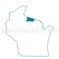
Outline

Summary
| Unique Area Identifier | 697363 |
| Name | CONOVER - T 3 Voting District |
| County | Vilas County |
| State | Wisconsin |
| Area (square miles) | 20.21 |
| Land Area (square miles) | 19.03 |
| Water Area (square miles) | 1.18 |
| % of Land Area | 94.16 |
| % of Water Area | 5.84 |
| Latitude of the Internal Point | 46.10374370 |
| Longtitude of the Internal Point | -89.27718570 |
Maps


Graphs
Select a template below for downloading or customizing gragh for CONOVER - T 3 Voting District, Vilas County, Wisconsin


Neighbors
Neighoring Voting District (by Name) Neighboring Voting District on the Map
- CONOVER - T 1 Voting District, Vilas County, WI
- LAND O LAKES - T 1 Voting District, Vilas County, WI
- PHELPS - T 2 Voting District, Vilas County, WI
- PLUM LAKE - T 2 Voting District, Vilas County, WI
Top 10 Neighboring County Subdivision (by Population) Neighboring County Subdivision on the Map
- Conover town, Vilas County, WI (1,235)
- Phelps town, Vilas County, WI (1,200)
- Land O'Lakes town, Vilas County, WI (861)
- Plum Lake town, Vilas County, WI (491)